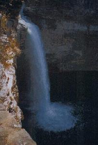
DeSoto Falls

- Water Source
- Little River
- Location
- About 12 miles from Fort Payne on County road 89 off
Alabama Highway 35, about 5 miles beyond the entrance to
De Soto State Park
Follow the signs to the falls from
route 35.
- Size
- 104 foot drop
- Trail
- The water is visible from the parking lot. There is a dam
at the edge of DeSoto Lake with water flowing over it. A
short walk allows you to see the first falls below the
dam. Farther along the walk you can see the large falls.
It is easily accessible, with just a short walk.
- Other Information
- This is a very impressive waterfall. According to the
guidebook I had, Alabama The Official 1995 Vacation
Guide, "Alabama in all her beauty is viewed
along a 12-mile road which edges Little River Canyon. The
falls plunge 104 feet from below DeSoto Lake. The canyon,
representing one of the deepest gorges east of the
Mississippi River, runs 16 miles within DeSoto State
Park."

Page last updated 28 Dec 2000.
Email comments to dmmaki@MichelesWorld.net

![]()