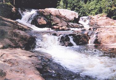
 This is the second falls I
found, which looked like the falls in the Michigan
Waterfalls book.
The directions from "Your Guide to Marquette County Lighthouses and Waterfalls" for Yellow Dog (Hills) Falls are as follow:
From Marquette - Travel County Road 550 north toward Big Bay, approximately 23 miles to County Road 510. Turn left (west) on County Road 510. Travel about 7 miles to the steel bridge across the Yellow Dog River. Park here on the left (south) side of the road. Follow the hiking trail on the south side of the river approximately 1/2 mile downstream. This is a nice walking trail with few ground obstacles. You will approach the falls from the top. (Note: View Big Pup Falls next).
I've received comments from viewers about these falls. Their comments are below:
- "According to your website, there is a descrepency between a Michigan Book of Waterfalls direction to Bushy Creek and a resident's direction. It appears that your first picture is really Yellow Dog (Yellow Hills) Falls and the second picture is Bushy Creek. I haven't been to Bushy Creek, but I just went to Yellow Dog Falls and the directions are almost identical to your first directions. I received my directions from Your Guide to Marquette County Lighthouses and Waterfalls. I hope this is helpful. Heather Klingelsmith Marquette Resident"
"I just wanted to give you a little added info on the Yellow Dog Falls. I think the name of the large falls on the Yellow Dog are the Yellow Dog Falls, the Brushy Creek Falls are down stream from the larger falls and are a small series of falls that form where the Brushy Creek flows into the Yellow Dog River. The name of the creek is the Brushy not the Bushy from all the maps that I have looked at. B. A. Reimer"
Return to Waterfalls in Marquette County I
![]()
Page last updated 07 Jun 2003.
Email comments to dmmaki@MichelesWorld.net