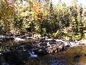
Tibbets Falls


County:
- Baraga County
- Water Source:
- Sturgeon River
- Drop:
- Series of drops up to 3-4 feet
- Location:
- 4.5 miles northwest of
Covington
- Directions:
- From US 141/M-28 about 2
miles west of Covington go north on Plains Road,
a blacktop road, for about 3 miles to the
Sturgeon River. Continue past the river a short
distance until Plains Road takes a sharp right
turn. There is a post at this spot where a trail
road continues straight ahead. Take the trail
road for about .2 miles to a fork (you will pass
another tail road on the left). Take the left
fork for about .5 mile to what appears to be a
parking area and the end of the road and the
beginning of a trail. Park there and walk down
the trail.
- Trail:
- The trail is an easy, short
walk down the hill from the trail road to the
river and the falls. There are blue diamonds on
the trees to mark the trail.
- Other Information:
- The trail road is a little
rough and takes you way back off the beaten path.
According to the Michigan Waterfalls book,
"In wet weather this trail road may not be
passable in a car." When I went there, the
road was dry, but if it was any worse I wouldn't
have wanted to venture down it. However, I had no
difficulties on it in my car.
-
- Note: When
I returned to Tibbets Falls in October 2006, the
trail road was blocked by a fallen tree, (see
first photo above) so I walked the short distance
to the parking area and beginning of the trail to
the falls.
-
- The photo above to the left
is the first photo I took of Tibbets Falls years
ago. The other photo are ones I took October 2,
2006 when I returned to the falls. I apparently
did not go as far downstream to get a view like
the one in the original photo.
-
-
Return to Waterfalls in Baraga County II
Return to Upper Michigan Waterfalls

Page last updated 07 Jan 2007.
Email comments to dmmaki@MichelesWorld.net

![]()